

Dorian lashes U.S, Bahamas
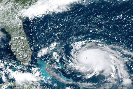
This GOES-16 satellite image taken Saturday, Aug. 31, 2019, at 16:00 UTC and provided by National Oceanic and Atmospheric Administration (NOAA), shows Hurricane Dorian, right, churning over the Atlantic Ocean. Hurricane Dorian bore down on the Bahamas as a fierce Category 4 storm Saturday, with new projections showing it curving upward enough to potentially spare Florida a direct hit but still threatening parts of the Southeast U.S. with powerful winds and rising ocean water that causes what can be deadly flooding.(NOAA via AP)
October 2, 2019
On Sept. 1, Hurricane Dorian first made landfall as a category five storm in the
Bahamas. The hurricane battered the island with 185 mph winds which makes it the worst natural disaster in the country’s history. For two days the hurricane moved at a speed of one mph across the northern Bahamas which caused mass destruction over the Great Abaco Island and the Grand Bahama Island.
Dozens were killed and more than 1,000 are missing in the wake of the storm that drove water through the islands, toppling homes and sweeping vehicles away,” NBC4 Meteorologist Benjamin Gelber said, via email.
Not only was the Bahamas affected by the storm, but the Southeast U.S. had coastal flooding and hurricane force wind gusts along the coastline.
“A seven-foot storm surge occurred when the storm made landfall over Hatteras, North Carolina, sending water as high as the second story of some homes on the Outer Banks,” Gelber said.
Dorian skimmed North Carolina as a category one storm with maximum sustained winds of 90 mph according to CoreLogic. The hurricane caused tornadoes and massive flooding on Ocracoke Island and the Outer Banks.
“Hurricanes form over warm seawater, at least 80 degrees, with weak wind shear aloft, which makes late summer peak storm season in the Atlantic basin. The Atlantic hurricane season runs from June 1 to Nov. 30. Hurricane Dorian developed explosively under optimal atmospheric conditions,” Gelber said.
Volunteers from across the state and the country have made progress on cleaning up the Outer Banks, and the northern end of Hatteras Island is now open to residents and visitors. Operation of local businesses will resume soon.
“It is really sad to see the places where I once was absolutely destroyed. Not only was it a shock to see the Outer Banks in the condition it was in, but also areas like Florida and the Bahamas have not been able to catch a break with the storms lately,” Camryn D. ‘22 said.
Hurricane Dorian is the strongest storm on record to occur east of Florida and the Atlantic. After striking the northern Bahamas, it matched the 1935 Labor Day hurricane for the strongest winds to make landfall, according to The Washington Post. At least 50 people were confirmed dead from the storm.
“I think the destruction of the Bahamas from the hurricane is horrible. So many families lost their homes and valuable; it was devastating overall to watch and hear about it in the news,” Lauren M. ‘20 said.


Ainsley • Dec 11, 2019 at 2:11 pm
This article was very informational and the picture was a really good visual.
Sophie Flowers • Dec 11, 2019 at 1:16 pm
I liked this article because I found it informative over what really happened with Hurricane Dorian because I did not know much about the topic, and now I know that it was a disaster for all the places involved especially because it was named as the worst natural disaster in the country’s history.